
An important part of any municipality's urban and community tree program is the "boots on the ground" inventory. From recording the overall species composition of your municipality's trees to estimating the age and size of canopy cover, a municipal tree inventory serves as a baseline for future tree planting and removal, maintenance needs, budgets, and heritage tree care. Most importantly, conducting a tree inventory brings everyone outside to closely observe trees and talk to the people who live, work, and play near them.
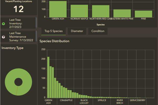
Municipal Tree Inventory Data conducted through VT UCF is public data collected both by, and for, municipal and public use. View a snapshot of existing inventory data on the Municipal Tree Inventory Dashboard or dive deeper into all municipal data with the Municipal Tree Inventory Web Map.
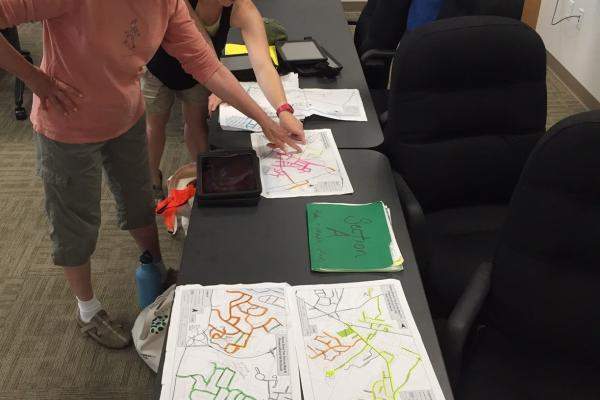
Municipal volunteers, staff, student groups, and non-profit groups can contact our program to receive free and in-person training to conduct a Municipal Tree Inventory using our digital platforms.
In these trainings, we discuss:
- Who will conduct the inventory
- What geography the inventory will encompass
- How to use the free applications ArcGIS Field Maps and ArcGIS Survey 123 to collect location, species, condition, and management guidelines about trees.
- How to take and view current and past photos of each tree in the inventory
- Any previously collected tree inventory data and how we can update it
- A plan and timeframe to update or complete each section of inventory
- How to view, sort, filter, and print data as it is collected and once field work is complete.
Inventory Options
-

Check Out the Dashboard
Peek at the inventory data already collected your municipality and see trends in species distrubtion, tree age, and tree condition. Filter by individual road names or by species to plan for planting.
-
Start Your Inventory
To schedule a training or ask questions about conducting a tree inventory in your community, contact Joanne Garton, Technical Assistance Coordinator for VT UCF, at joanne.garton@vermont.gov or (802) 249-4217.
-
Use Your Data
Has your community already used the Municipal Tree Inventory tool to enter trees into the database? Use the interactive map to filter and display information about these trees in ways most useful to you.
-
Focus on Ash Trees
Learn more about roadside ash inventory and planning for the impact of emerald ash borer in municipal rights-of-way along rural roads.

Completed Inventory Reports
Barre City (2015)
Brattleboro (2015)
Bristol (2014)
Charlotte (2016)
Chester (2016)
Colchester (2012-13)
Essex Junction (2013-14)
Hinesburg (2015)
Hyde Park (2017)
Irasburg (2021)
Johnson (2014)
Lyndonville (2015)
Middlebury (2014) Inventory Update (2016)
Milton (2015)
Newport City (2016)
Northfield (2014)
Plainfield (2015)
Rockingham (2015)
Shelburne (2014)
Springfield (2015)
St. Albans City (2015)
Stowe Village (2016)
Swanton (2014)
Thetford Hill (2018)
Vergennes (2014)
Waterbury (2016)
Windsor (2016)
Winooski (2014) Inventory Update (2015)