Does your municipality or community forest already have information visible in the Municipal Tree Inventory Dashboard and Municipal Tree Inventory Web Map? If so, you're ready to learn more about using all of the tools available to you for free via our interactive websites.
Watch the webinar or review the slides linked below to learn how to:
- view, filter, and sort points on the map
- export your data as a spreadsheet
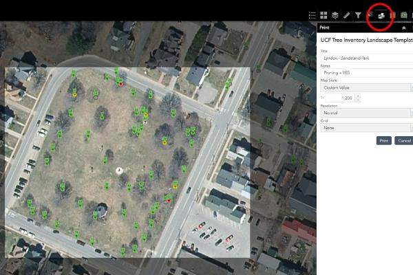
- print customized maps of trees in public ways and places
- create tree reports including details about management and maintenance
- work with georeferenced files (in ArcGIS or another GIS software) to customize your maps even more, or
- link other people to your municipality's collected tree inventory data.
For Regional Planning Commission staff or other GIS software users, visit the Vermont Open Geodata Portal and search for "Municipal Tree Inventory" to access georeferenced files.
If you have not yet collected any digital inventory data using our program's municipal tree inventory project, contact Joanne Garton, VT UCF Technical Assistance Coordinator, to schedule a virtual or in-person training and receive the Municipal Tree Inventory User Guide by email.
-

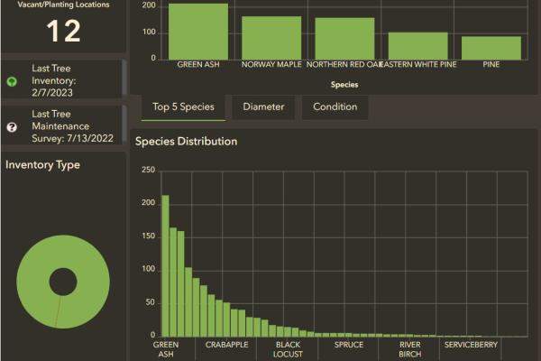
Check Out the Dashboard
Take a quick peek at trends in your municipality's collected data.
-
Watch the webinar
Spend 30 minutes on a walk-through of how to map, filter, and share your tree inventory data in the way that's most useful to you.
-
Use the Web Map
View, filter, sort, and print your tree inventory on this interactive map.
-
View the slide show
Prefer to read your instructions? View the webinar slideshow here.