
March 19, 2019
The following article was featured in the spring edition of City Trees Magazine, a publication of the Society of Municipal Arborists. View the article as it appears in print. Learn more about our Resilient Right-of-Ways project.
In a state with only nine cities and thousands of tree huggers, Vermont’s image does not struggle to be green. Over 4.5 million acres (1.8 million ha) of the state (and Vermont is only 6.1 million acres/2.5 million ha large) are covered by forests— forests that sequester and store carbon, provide wildlife habitat, clean surface water, and create healthy soil. Vermont trees support our forest economy, fuel fall foliage tourism, sweeten our meals with maple syrup, and provide our refuge. In part, people come to Vermont to see its forests; many stay in Vermont to call them home.
As such, the six staff that compose the entire Vermont Urban & Community Forestry (UCF) Program may seem too few to properly represent the enthusiasm of the Green Mountain State. Delivering educational, technical, and financial support to town-appointed tree wardens, volunteer tree and town forest committees, and the state’s handful of city arborists, Vermont’s UCF team supports healthy and innovative green space design at the level a town can engage. It connects people to trees, brings green infrastructure to gray streets, and empowers citizens to care for their public spaces.
But by both necessity and design, Vermont UCF spreads its wings farther than urban streets. It is small and nimble, meeting Vermonters where they are, whether in farm fields, mountainous roads, lake edges, town forests, or village parks. Yes, urban and community forests are city trees. But in Vermont, they’re also all public trees. They are the trees that take up no more than a passing glance on a commute home. They are the trees that line our farm fields. They are trees that fall on the road during an ice storm, trees that tangle their branches in power lines, and trees that show their shallow roots after a windstorm. Strange in shape and character, Vermont’s unsung trees are as valuable as its centerpieces.
In recognition of the services provided by this expanded view of urban and community forests, Vermont’s UCF Program is presently tackling a strange swath of public space: the right-of-way. Often the burden of small-town local road crews, municipal right-of-way vegetation covers over 27,000 acres (11,000 ha) along Vermont’s rural roads alone. Neither a park nor a wildlife refuge, this untamed vegetation either bounces back as soon as the mower is turned off or refuses to grow no matter what seeds are planted. At its best, the right-of-way vegetation features centuries-old maples bordered by vibrant shrubs and ephemeral wildflowers; at its worst, this strip of publicly managed land overflows with non-native grasses tangled with invasive knotweed, failing trees, and stick-thin beech thickets.
The Resilient Right-of-Ways project empowers Vermont cities and towns to think carefully about the value of their roadside trees and plants, the means they have to support their healthy growth, and the vision they create for the future of their community forests. An inspirational label, the term “resilient” will mean many things to many communities. To a city with competing funding interests, a Resilient Right-of-Way will be both effective stormwater management and good PR for its downtown liveability. To a rural town, the same catch phrase may encompass a refined mowing plan, an invasive plant strategy, or a public outreach campaign about emerald ash borer and the hundreds of town-managed backroad ash trees.
Funded by the USDA Forest Service, this three-year initiative engages 10 urban areas and 10 rural communities in diverse right-of-way assessments and planning efforts. Spurred by mounting pressures to restore the massive impaired watershed that feeds Lake Champlain, the Resilient Right-of-Ways project in urban areas examines barriers to adoption and maintenance of green stormwater infrastructure (GSI) at the municipal level. In some cases, this requires sifting through unclear or conflicting municipal regulatory language pertaining to landscaping, zoning, development, and operations. The Vermont League of Cities and Towns, a non-profit and nonpartisan organization that serves municipal governments, steps in to complete a thorough municipal bylaw review and offers guidance on resolving discrepancies and strengthening language in support of GSI. The project’s graphic designer develops a suite of photo simulations of GSI practices that support proposed or existing bylaw language in each town. To accompany the direct technical assistance, the 2018 Green Streets Vermont Guide provides both instruction and inspiration, preparing cities and towns statewide to create ecologically functional right-of-way design.
The Resilient Right-of-Ways project in rural towns focuses on the broad array of roadside scenarios found along Vermont’s backroads. Both conflict and opportunity arise where our miles of unpaved roads wind their way through deep forests, grown-in pasture, expansive wetlands, and growing development. Vegetation is stuck in a stage of early succession, subjected to repeated clearing, sand, salt, airborne sediment, and vehicle exhaust. Invasive plants easily squirrel their way along exposed roadside soil and forest pests, such as the new-to-Vermont emerald ash borer, touch the edge of our built environment.
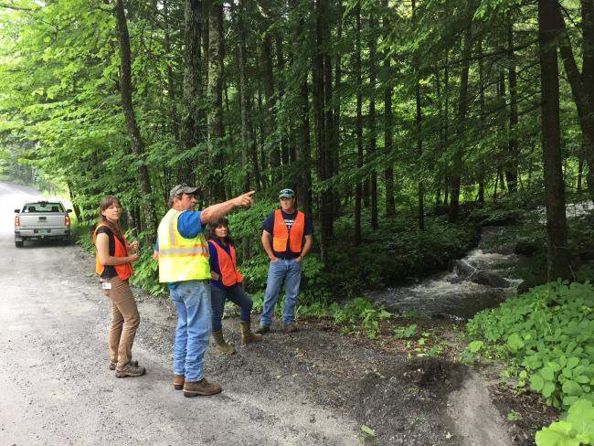
For the rural town project partners, Vermont UCF staff captures the current state of typical sections of right-of-way. Data collection records the existing influences in the right-of-way: the presence of utility lines, the extent of mechanical damage to trees and shrubs, the health of the overstory, the identity and distribution of invasive plants, the presence of active agriculture in the right-of-way, and the health and location of historic trees. The staff then guides towns towards a future roadside condition that incorporates recommended forestry techniques, risk management goals, stormwater infrastructure upgrades, and preservation of aesthetic and cultural values. Recommended action items also consider existing and neighboring land uses, ultimately highlighting select areas in town that would benefit from tree planting, restoration, preservation, thinning, risk management (particularly in regard to tree mortality due to EAB), or other silvicultural practices.
One hundred and fifty years ago, Vermont’s landscape was largely pasture, a result of deforestation that occurred to support agriculture and a booming sheep industry. Until these industries declined, forests seemed expendable and erasable. Today, after over a century of reforestation, Vermont’s forests are declining in acreage again. The historic pattern of village centers surrounded by agricultural fields has eroded into sprawling cities encircled by shrinking and fragmented forests. Single homes and small developments dot the landscape and over 15,000 miles (24,000 km) of roads criss-cross the stands of once contiguous, although young, forest.
Despite these patterns, we do now know the true value of our forests. Because public trees weave their way in and out of our built environment, we recognize that the stewards of our trees are not just foresters— they’re on planning commissions, leading road crews, writing municipal laws, engineering stormwater solutions, and running farms. In a state of few cities and many trees, Vermont UCF is learning that our audiences are diverse and our partnerships must be broad. Understanding the continuum of all of our urban and community trees is essential to supporting vibrant social and ecological communities. Small but mighty, the Vermont Urban & Community Forestry Program strives to promote these public green spaces, no matter what their shape or size, and bring our forest pride to the everyday spaces we inhabit.